Lot 4
Asia and Oceania. – 11 travel guides.
Estimate
€ 300
Starting Price
€ 200
Hammer Price
€ 500
Lot:
4
Category:
Geography and work of views
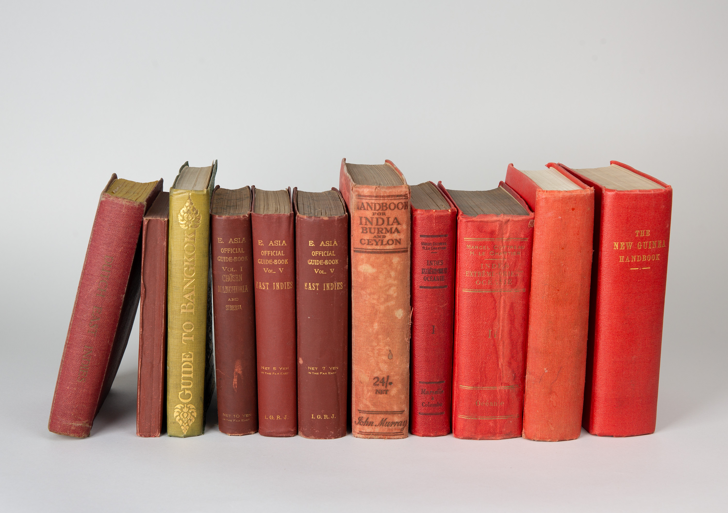
11 travel guides to Asia and Oceania.
15 to 18 x 10 to 13 cm. Original bindings.
(Slight signs of age and wear.)
1) An Official Guide to East Asia. Vol. I. Chōsen, Manchuria and Siberia. Second Edition, Tokyo: The Department of Railways, 1920. With numerous folded colour maps and plans, and several full-page plates.
2) An Official Guide to Eastern Asia: Transcontinental Connections between Europe and Asia, Vol. V. East Indies, including the Philippine Islands, French Indochina, Siam, the Malay Peninsula and the Dutch East Indies. Tokyo: Imperial Government Railways of Japan, 1917. With a large, colour, multi-sheet general map that is folded to show the Dutch East Indies and other maps and plans.
3) An Official Guide to Eastern Asia: Transcontinental Connections between Europe and Asia, Vol. V. East Indies, including the Philippine Islands, French Indochina, Siam, the Malay Peninsula and the Dutch East Indies. Second Edition. Tokyo: Department of Railways, 1920. With a large, colour, multi-fold general map of the Dutch East Indies and other maps and plans. Includes 2 visitor tickets to Angkor Wat.
4) Reitsma, S. A.: Van Stockum’s Travellers’ Handbook for the Dutch East Indies. The Hague: W. P. van Stockum & Son, 1930. With folded plans and maps.
5) India, Burma, Ceylon and South Africa. Information for Travellers and Residents. London: Thos. Cook & Son (1905).
6) Seidenfaden, Erik: Guide to Bangkok with notes on Siam. Second Edition. Bangkok: Royal State Railways of Siam 1928. With 3 colour plates, 1 folded colour map and illustrations in the text, many of which are full-page.
7) A Handbook forTravellers in India Burma and Ceylon including all British India, the Portuguese and French Possessions, and the Indian States. Twelfth Edition. London: J. Murray 1926. With 86 folded colour plates and maps. (Shows heavy signs of wear.)
8) Guides Pratiques et Pittoresques en Trois Parties. Indes, Extrême-Orient, Océanie.1re Partie De Marseille à Colombo. Paris: Librairie du Tourisme o. J. Includes colour maps and plans, some of which are enclosed in map pouches.
9) Indes, Extrême-Orient, Océanie. 2e Partie. De Ceylan en Océanie. Paris: Librairie du Tourisme n. d. Includes colour maps and plans, some of which are enclosed in map pouches.
10) Official Handbook of the Territory of New Guinea administered by The Commonwealth of Australia under Mandate from the Council of the League of Nations. Canberrra: L.F. Johnston (c. 1936). Includes a large, multi-page, folded colour overview map and other maps and plans. A supplement is enclosed in the back pocket.
11) Official Handbook of the Territory of New Guinea administered by The Commonwealth of Australia under Mandate from the Council of theLeague of Nations. Canberra: L. F. Johnston 1943. Reprint of the 1936 edition. Includes a large, multiple-folded colour overview map and further maps and plans. 3 supplementary booklets enclosed in a pocket at the back.
Not carefully collated. No right of return.
15 to 18 x 10 to 13 cm. Original bindings.
(Slight signs of age and wear.)
1) An Official Guide to East Asia. Vol. I. Chōsen, Manchuria and Siberia. Second Edition, Tokyo: The Department of Railways, 1920. With numerous folded colour maps and plans, and several full-page plates.
2) An Official Guide to Eastern Asia: Transcontinental Connections between Europe and Asia, Vol. V. East Indies, including the Philippine Islands, French Indochina, Siam, the Malay Peninsula and the Dutch East Indies. Tokyo: Imperial Government Railways of Japan, 1917. With a large, colour, multi-sheet general map that is folded to show the Dutch East Indies and other maps and plans.
3) An Official Guide to Eastern Asia: Transcontinental Connections between Europe and Asia, Vol. V. East Indies, including the Philippine Islands, French Indochina, Siam, the Malay Peninsula and the Dutch East Indies. Second Edition. Tokyo: Department of Railways, 1920. With a large, colour, multi-fold general map of the Dutch East Indies and other maps and plans. Includes 2 visitor tickets to Angkor Wat.
4) Reitsma, S. A.: Van Stockum’s Travellers’ Handbook for the Dutch East Indies. The Hague: W. P. van Stockum & Son, 1930. With folded plans and maps.
5) India, Burma, Ceylon and South Africa. Information for Travellers and Residents. London: Thos. Cook & Son (1905).
6) Seidenfaden, Erik: Guide to Bangkok with notes on Siam. Second Edition. Bangkok: Royal State Railways of Siam 1928. With 3 colour plates, 1 folded colour map and illustrations in the text, many of which are full-page.
7) A Handbook forTravellers in India Burma and Ceylon including all British India, the Portuguese and French Possessions, and the Indian States. Twelfth Edition. London: J. Murray 1926. With 86 folded colour plates and maps. (Shows heavy signs of wear.)
8) Guides Pratiques et Pittoresques en Trois Parties. Indes, Extrême-Orient, Océanie.1re Partie De Marseille à Colombo. Paris: Librairie du Tourisme o. J. Includes colour maps and plans, some of which are enclosed in map pouches.
9) Indes, Extrême-Orient, Océanie. 2e Partie. De Ceylan en Océanie. Paris: Librairie du Tourisme n. d. Includes colour maps and plans, some of which are enclosed in map pouches.
10) Official Handbook of the Territory of New Guinea administered by The Commonwealth of Australia under Mandate from the Council of the League of Nations. Canberrra: L.F. Johnston (c. 1936). Includes a large, multi-page, folded colour overview map and other maps and plans. A supplement is enclosed in the back pocket.
11) Official Handbook of the Territory of New Guinea administered by The Commonwealth of Australia under Mandate from the Council of theLeague of Nations. Canberra: L. F. Johnston 1943. Reprint of the 1936 edition. Includes a large, multiple-folded colour overview map and further maps and plans. 3 supplementary booklets enclosed in a pocket at the back.
Not carefully collated. No right of return.